
This is the map of our local area. The big city of Braymer, Missouri is the pinkish spot in the upper right (north east) quadrant.
When I was promoted into the ranks of a Non-commissioned Officer in our United States Army these many years ago, this newly formed Buck Sergeant was taken aside and taught the first absolute of being a good Sergeant. A crusty Platoon Sergeant with a marked Spanish accent said, “Sergeant, you will NEVER let a 2d Lieutenant hold the map and the compass at the same time.”
Land Navigation, as the Military calls it, is a vital skill and it starts with understanding what you are dealing with. I am not going to have the time or the space to teach you how to navigate using a map and a compass, the best I can do is list the skills necessary to navigate with a map and a compass. Perhaps I can also highlight some common errors people make.
For more in-depth information I am going to refer you to Field Manual (FM) 3-25.26 Map Reading and Land Navigation.
Also, for good cheap or even free Topographical Maps I suggest you look up the United States Dept of the Interior Geological Survey. These are the kind of maps that, when I say “map” I am talking about.
1. A compass is a device that points to magnetic north. For the purpose of using a map there are THREE different norths:
a. Magnetic north is governed by the magnetic pull of the earth that draws your compass needle towards it. It is located generally around Hudson Bay but it moves.
b. True north is the actual point of north. The Top of the World if you will.
c. Grid north is where your map’s grid lines point to as north.
At the bottom of any good map there should be some kind of declination diagram or at least a pointer that points to true north. On short trips the difference between true north and magnetic north should not cause you much error. In Missouri the declination is 1degree 6 minutes east which I determined by visiting this site. This means that, to adjust to true north I am going to have to subtract 1.6 from my compass heading.
Are we confused yet?
Let’s talk about compasses. I prefer the Lensatic Compass that is issued by the military, because it is accurate and designed for use in the worst kind of conditions. However, any decent magnetic compass will do as long as you know how to use it.
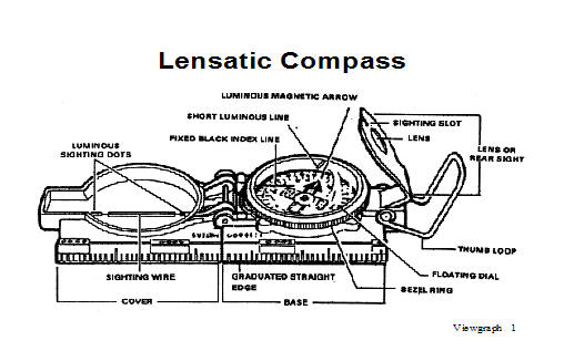
U S Army Illustration
The compass on your watch band, in your fancy survival watch, the handle of your knife or the one you got out of a cereal box is probably OK for determining general direction, and it is better than nothing in a pinch, but I would not like to walk twenty-five miles using that type of compass to choose my direction.
2. Lets talk about maps for a minute. For my purposes, I am talking about a to scale two dimensional representation of a three dimensional surface of the earth. (I can remember that definition from twenty years ago but I cannot remember where I left my hat. Sigh)
That kind of map is a topographic map which shows elevations, vegetation, bodies of water, and man made objects. Anything less is going to give you problems choosing a good route.
So we have our map in our hands and our compass hanging by a lanyard around our neck. Lets talk about one of the major errors we all tend to make when trying to read a map. I named this error “The North Seeking Jeep”.
People have a tendency to believe that once they lay the map out, the top of the map (representing north) is oriented to the north. So people sitting in their jeeps (yes, I mean officers), have a tendency to believe whatever direction their jeep is facing is north. It probably isn’t.
To orient your map you can use your compass or you can use major linear terrain features you can see (roads, creeks, mountain ranges, power lines etc). The best way is with your compass. Factoring in your declination laying your compass along a north-south grid line and turn the map with the compass until the compass point to north. Until you know how your map relates to the cardinal directions, you better get used to long useless walks. By the way, Connie pointed out some people might not know what I mean by “cardinal directions”. Due North, South, East and West are your cardinal directions. Red birds have nothing to do with it.
There will be symbols and colors on your map. If you are using a Topographic Map from the Geological Survey folks, the symbols and colors are largely standard, but on any map they should be listed at the bottom of the map. Also you will find your contour intervals (the distance in elevation between contour lines) and your scale.
So we have our map. We have read it so we know what the different symbols and colors mean. We know the scale of the map and we have oriented it using our compass, after accounting for the declination, and we are ready to go.
Hold on a second. How far are you going to go, and how will you know how far you have gone? You can use the features on your map to estimate how far you have gone, but sometimes there is not that much difference in terrain features over an extended distance; deserts and plains for example. Now you need a method of measuring how far you have gone, and to do that you need to know your pace count.
In a military patrol two men are assigned to keep up with their pace. Generally they use a piece of para chord tied to their web gear in which they tie a knot every 100 meters. You may not need to use this technique where you are orienteering, but when you do need to use it, you need it badly.
So mark off a hundred meters over terrain, not down a flat highway, and find out your pace count. A true pace is a full two steps. If you step off with your left foot the second time your left foot hits the ground is one pace. My step is generally around 30 inches, and my pace count always came out to about 65 paces per 100 meters.
Oh, one last thing you will need to know. How to find places on your map using the grid system on the map and, in a pinch, the longitude and latitude system. I could try to explain it to you here, but I doubt either one of us have the patience for that. Get the FM I suggested or any other good orienteering\book. Get a map, get a good compass, and prepare to get lost.
Of course you are going to get lost. We all get lost. Orienteering is being lost, interspersed with occasional clarity as to where you are. Kind of like life.

Ha. This took me back to my U.S.M.C. days. You’ve written a good post, but for folks that aren’t familiar with land nav that manual is a must for sure. Once you get into shooting an azimuth, counting pace and shooting a back azimuth the triangulate your position….that’s going to burn out a few circuits from some brain housings…it’s a useful skill to learn.
LikeLike
Absolutely, they need a lot more information and a chance to get out and get lost in a friendly environment where the buggers won’t get ’em. All I could do is introduce them to the subject. Next year I hope to teach my step-daughter who we are home schooling how to find her way around with and without a map. Thank you for your kind words.
LikeLike
Pingback: Endangered Skill 8: Making Do With What You Have | Old Folks at Homestead